Kartoza - The Evolution of GIS: From Humble Beginnings to Modern Tech
In this article, we explore the milestones that have defined GIS over the years and reflect on how these tools continue to empower decision-makers, educators, and communities.
Geographic Information Systems (GIS) have come a long way since the mid-20th century, evolving from simple mapping tools into powerful technologies shaping industries and societies worldwide. At Kartoza, we recently found ourselves diving into this evolution during a lively office discussion sparked by Geography Awareness Week and GIS Day. These annual events celebrate the value of geography and GIS in understanding our world.
In this article, we explore the milestones that have defined GIS over the years and reflect on how these tools continue to empower decision-makers, educators, and communities.
The Early Days of Spatial Analysis (GIS)
Manual Mapping and Limited Capabilities
In the mid-20th century, GIS was a labour-intensive process. Analysts relied on paper maps, rulers, and manual calculations to derive spatial insights. Early GIS was limited to basic data overlays, often drawn by hand on transparent sheets. The process was time-consuming, error-prone and lacked the dynamic capabilities we now take for granted.
The Birth of GIS Software
The 1960s marked the inception of digital GIS. Dr. Roger Tomlinson, often called the "Father of GIS," developed the Canada Geographic Information System (CGIS) to manage Canada’s land inventory. The CGIS could store, analyse, and retrieve spatial data—an innovation that laid the groundwork for modern GIS.
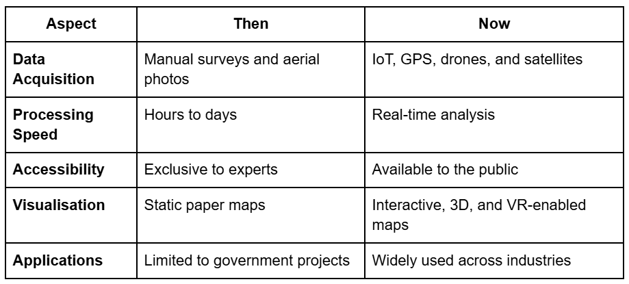
However, early GIS systems were confined to government and research institutions due to their high cost and the need for specialised equipment. Data processing was slow, with results often requiring hours or even days to generate.
Data Scarcity and Accessibility Issues
Before satellites and GPS, data acquisition was a significant challenge. Surveys, aerial photography and physical measurements were the primary sources of geographic data. These methods were resource-intensive and limited the scope of GIS applications.
A Future of GIS Possibilities
Advanced Technology and Accessibility
Modern GIS has undergone a digital revolution. Today, GIS systems leverage advanced technologies such as cloud computing, artificial intelligence (AI) and machine learning to process vast amounts of data in real-time. Tools like ArcGIS, QGIS and Google Earth have democratised access, enabling individuals, businesses and governments to use GIS for a wide range of applications.
Real-Time Data Integration
The integration of Internet of Things (IoT) devices, GNSS and satellite imagery has enabled real-time data collection and analysis. Whether tracking the spread of disease, optimising delivery routes or monitoring environmental changes, GIS systems now provide dynamic, actionable insights.
Data Visualisation and User Experience
Gone are the days of static maps. GIS platforms now feature interactive dashboards, 3D modelling and virtual reality environments, making data visualisation more intuitive and engaging. These advancements allow even non-experts to interpret complex spatial data effectively.
Applications Across Industries
GIS has expanded far beyond its original scope. Today, it supports industries like urban planning, agriculture, disaster management, logistics and retail. For example:
- Agriculture: Precision farming techniques use GIS to analyse soil conditions and optimise crop yields.
- Retail: Businesses use GIS to identify prime store locations based on demographic and geographic data.
- Disaster Management: GIS helps predict natural disasters, plan evacuations and assess damage in real-time.

Left: MyFarmWeb is an interactive, cloud-based platform, accessed through any browser, for storing, visualizing and comparing all types of maps, geographic and IoT generated agricultural data.
Middle: interactive online map for the Cape Town Marathon, open source QGIS plugin, InaSAFE, for disaster management
Key Differences: Then vs. Now

The Road Ahead
The future of GIS promises even greater innovations. With the advent of artificial intelligence, GIS systems will become more predictive, enabling proactive decision-making. Technologies like augmented reality (AR) and the metaverse could bring immersive GIS experiences, revolutionising how we interact with spatial data.
Moreover, as sustainability becomes a global priority, GIS will play a crucial role in addressing climate change, optimising resource use and protecting biodiversity.
Conclusion
From analogue maps to AI-driven insights, GIS has come a long way. Its evolution reflects our growing ability to harness technology for understanding and improving the world around us. As GIS continues to advance, its potential applications are limited only by our imagination.
Whether you’re a researcher, a business leader, or a curious explorer, GIS today offers tools and insights that were unimaginable just a few decades ago. With the pace of technological innovation, the best is yet to come.
Michelle von Maltitz
Michelle holds an honours degree in Geographic Information Systems (GIS) and through her experience in the work environment has developed a passion for project management for which she now holds several qualifications. She is an experienced project manager with 10 years of success leading all phases of diverse multi-million-rand projects within the field of GIS and Aerial Survey. She is comfortable trying innovative methods and new techniques in her project management style. Her key strength lies in being focused and disciplined in her work approach, coupled with a result driven approach that boosts propensity for continuously seeking ways to add value and take the initiative in improving processes. When she is not working, you are liking to find her somewhere in the mountains.

No comments yet. Login to start a new discussion Start a new discussion