Land Information System for Ogun State, Nigeria
Ogun State in Nigeria started implementation in 2012 of their first digital Spatial Data Infrastructure (SDI). At its core are new Land Information and Land Administration Systems, of which Kartoza was the core developer.
Description
Ogun State in Nigeria started implementation in 2012 of their first digital Spatial Data Infrastructure (SDI). At its core are new Land Information and Land Administration Systems, of which Kartoza was the core developer. Data are housed in PostGIS and published using Geoserver and PHP in a custom implementation of the 1map platform (http://1map.co.za).
The core requirements were to:
• Provide infrastructure, tools and training to digitise all the historical paper cadastral records of Ogun State
• Provide tools, workflows and training for staff to conduct examinations for property transactions and applications.
• provide a geo-portal (SDI) for Ogun State Government containing all core data sets required by the government.
Kartoza conducted requirements analysis, designed the system, implemented a localised instance of 1Map (PHPand front-end customisation was done by 1Map), prepared and published all the geo-portal datasets in PostGIS and GeoServer and provided training.
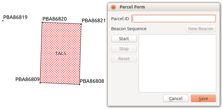
Kartoza also developed a QGIS Python plugin (https://plugins.qgis.org/plugins/parcel_plugin) and associated PostgreSQL database to assist with the rapid and accurate capture of cadastral beacons and parcels, including bearing and distance (COGO) capture. Editing takes place directly on the SDI database and the results are instantly visible to web portal users.
Kartoza conducted requirements analysis, designed the system, implemented a localised instance of 1Map (php and front-end customisation was done by 1Map), prepared and published all the geo-portal datasets in PostGIS and GeoServer and provided training.
Kartoza also developed a QGIS Python plugin (https://plugins.qgis.org/plugins/parcel_plugin) and associated PostgreSQL database to assist with the rapid and accurate capture of cadastral beacons and parcels, including bearing and distance (COGO) capture. Editing takes place directly on the SDI database and the results are instantly visible to web portal users.§
Completed: 2014-08-01


