Kartoza - Disaster Management with QGIS and the InaSafe Plugin
In the ever-evolving landscape of disaster management, having the right tools to anticipate and respond to disasters can be the difference between preparedness and chaos.
Enhancing Disaster Management with QGIS and the InaSafe Plugin
In the ever-evolving landscape of disaster management, having the right tools to anticipate and respond to disasters can be the difference between preparedness and chaos. One such tool that has been making waves is InaSafe, an open-source plugin for QGIS designed to produce realistic natural hazard impact scenarios for better planning and response.

At the GISSA Gauteng session earlier this year, I demonstrated how InaSafe can empower disaster management professionals. My talk focused on how the tool can be used in practical, real-world scenarios, specifically through the analysis of flood events. Here’s a breakdown of my key points and insights from the session.
What is InaSafe?
InaSafe is a plugin that allows users to conduct impact assessments based on hazard and exposure data, like floods, earthquakes, or volcanic eruptions. The tool was developed to provide actionable information to help in making informed decisions during disaster management planning. One of InaSafe’s most powerful aspects is its ability to model different disaster scenarios and provide detailed analyses of their impacts on communities, infrastructure and the environment.
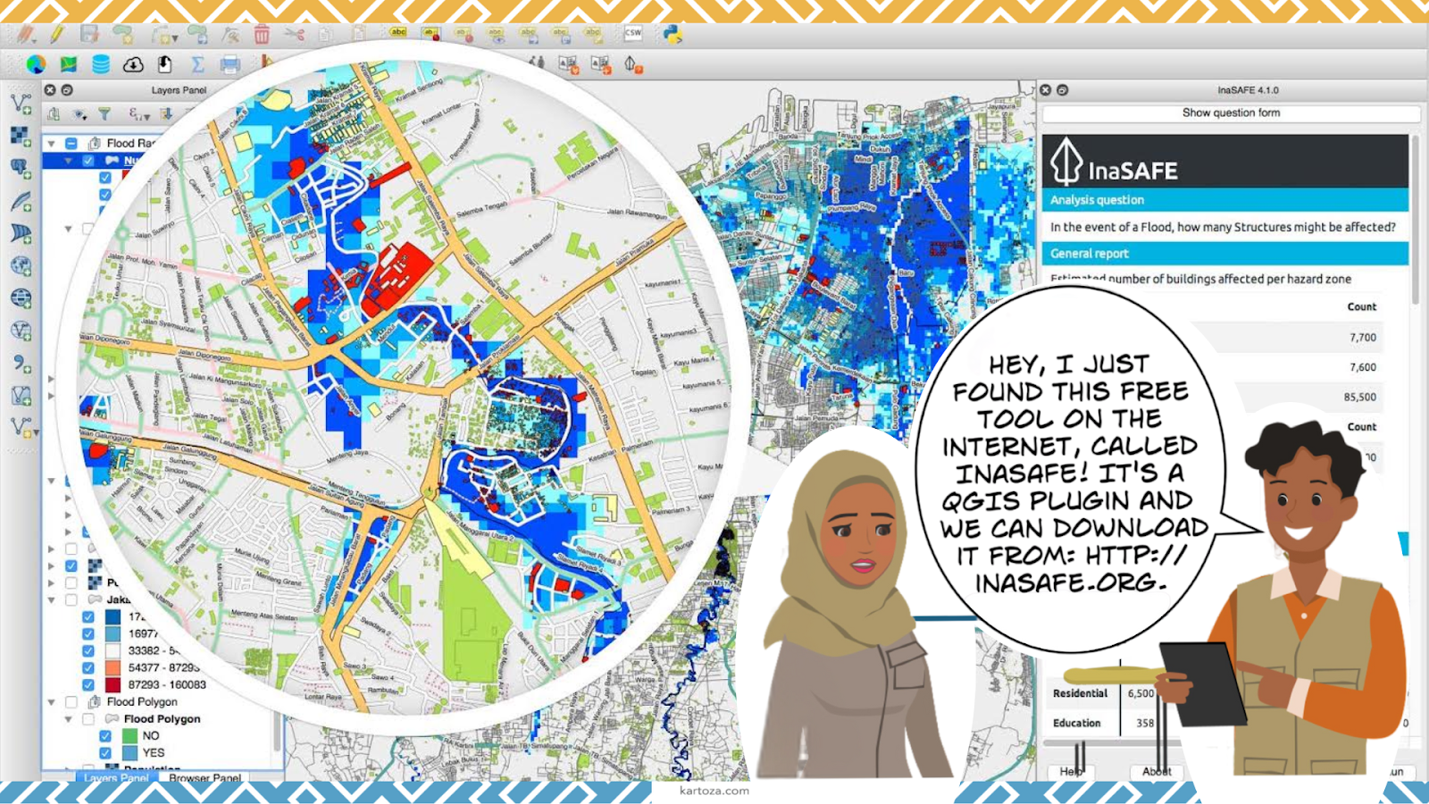
Website: InaSafe.org
Manual and Resources: InaSafe User Manual
The Power of Simple and Complex Analyses
During the session, I performed two different types of flood analysis to highlight the versatility of InaSafe.
Key Benefits for Disaster Management
- Real-World Applications: InaSafe isn’t just theoretical—it’s actively used in disaster-prone regions around the world, from Southeast Asia to Africa. Governments, NGOs, and disaster response teams leverage it to improve preparedness and risk mitigation strategies.
- Customisable Outputs: InaSafe allows users to generate tailored impact reports. These reports can include detailed statistics, maps, and charts, making it easy to communicate risks and necessary actions to decision-makers and stakeholders.
- Community Driven: The tool is open-source and free, with a global community contributing to its development. This ensures that InaSafe stays up to date with the latest disaster management needs and best practices.

How to Get Started with InaSafe
If you're interested in exploring the power of InaSafe for your own disaster management needs, here’s a simple guide to get started:
Install the Plugin: InaSafe is available as a free plugin in QGIS. You can install it directly through the QGIS plugin manager.
Explore the Plugin: Familiarise yourself with the tool by exploring the various hazard and exposure datasets available.
Conduct a Simple Analysis: As demonstrated in the session, start with a basic hazard layer (e.g., flood, earthquake) and use the plugin to assess impacts on your region of interest.
Dive Deeper with Complex Analyses: For those looking to conduct more advanced studies, InaSafe supports custom inputs, more detailed parameters and sophisticated simulations.
1. Simple Analysis

We began with a basic flood scenario, demonstrating how easy it is to run an analysis using InaSafe once the plugin is installed in QGIS. For this exercise, I used predefined hazard and exposure layers, quickly generating an impact report. The simplicity of this analysis underscores InaSafe's accessibility for users, even those new to QGIS or GIS analysis. In just a few clicks, you can produce meaningful insights about potential flood impacts, helping first responders prioritise actions.
2. Complex Analysis

I then shifted to a more intricate analysis, integrating multiple datasets and refining parameters to simulate a more realistic and high-stakes flood scenario. This demonstrated InaSafe's capacity to handle complex scenarios where greater detail is needed—such as assessing the potential displacement of populations, the impact on critical infrastructure like roads and hospitals, or the number of affected households. The results of these analyses showed the breadth and depth of InaSafe’s capabilities. The tool can be used to assess anything from small, localised events to large-scale disasters with widespread impacts.
Wrapping Up


As we face an increasing number of natural disasters, tools like InaSafe are essential in helping us prepare, respond, and ultimately save lives. Whether you're a GIS professional or a disaster management planner, InaSafe provides a powerful, accessible platform to better understand the impacts of disasters before they strike. With its combination of simplicity and depth, it’s a tool that can truly transform the way we approach disaster management.
Amy Ternent
Amy is a Graduate Environmental scientist. She has an Honours degree from the University of Pretoria and a Masters in Environmental Science from The University of the Witwatersrand. She Works at Kartoza as a Junior GIS specialist and GIS Technician. Amy is passionate about the environment and using GIS to solve complex ecological and environmental issues. She is also creative and enjoys nothing more then making beautiful and functional maps using open source technology. She also enjoys creating and editing videos and other multimedia projects for education and inspiration. She loves creating social media content and interacting with the vibrant QGIS and open source community through Open days and other initiatives.In her spare time Amy can be found hiking, camping, birding or on almost any outdoor adventure. When she is not hiking up a mountain, she enjoys slowing down with a number of creative pursuits, including drawing, embroidery, and laser engraving / cutting her latest designs.


No comments yet. Login to start a new discussion Start a new discussion